gpx-files of the path
gpx-files with points of interest
Published: 2026-01-14
Updates:
2026-04-01: GPX-files for the complete Nakasendō, the nine stages, all the post towns, as well as the path for the Early Nakasendō.
2026-04-02: GPX-file for the ichirizuka (milestones) and sekisho (barrier gates) along the Nakasendō. GPX-file for a number of non-official post stations.
2026-04-06: Correction to the Nakasendō Post station file.
2026-04-07: Individual legs, as well as alternate paths
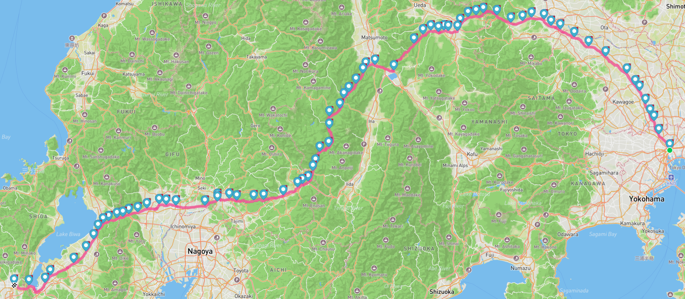
The old Nakasendō path between Tokyo and Kyoto winds its way across a varied landscape. It will take you over forested mountain passes, along meandering rivers, through cityscapes of glass, concrete and steel, past small villages on the outskirts of civilisation, and via sometimes endless suburbs of some of the largest cities in the world. The path is sometimes signed, and then often with a bewildering variety of signs. Some stretches are well signed and easy to follow. Others have no signs at all. This means that sometimes you can rely on the signs to find your way, but also that often you cannot. This is where the GPX-files come in handy.
The Nakasendō was defined in 1603, but has been through a number of changes over the years. One of the biggest changes to the layout of the path was made after only about 10 years, in 1614 and concerned the passage between Shimosuwa-shuku and Niekawa-juku. The old layout, which is now called the Early Nakasendō passed through Ono-juku, while the newer path instead headed through Shiojiri-shuku, Seba-juku, and Motoyama-juku. This change was ostensibly made because the new path was easier, but had more likely political reasons. Having the Nakasendō pass near your domain could be lucrative. The Early Nakasendō gpx-file details a reconstruction of the original path between Shimosuwa and Niekawa via Ono, as it was designated in 1603. Note that this early version of the Nakasendō had its own set of ichirizuka. The location of these abandoned milestones will be uploaded in a separate gpx-file further on! These files are numbered in the same way as the normal gpx-files for each stage between the post stations.
The zip-file with the nine stages showcases a sometimes unhistoric division of the Nakasendō. While the Kiso valley (the Kisoji), and the Higashi-Shinshu Nakasendō were named stretches during the Edo period, stages like the South of the Kiso river has been made up by this site. These nine stages try to help differentiate the various sections of the path, and make it easier to understand the challenges and experiences along the hike.
The 70 legs file contains seventy GPX-files, one for each leg between the 69 post stations, as well as the start and end points.
The alternate paths aren’t meant to re-write the layout of the Nakasendō completely. Instead, they offer variations to the path which might be of interest to some hikers, or where the official path is particularly unfriendly to people on foot. For instance, sometimes a leg on the Nakasendō follows a busy highway with little to no room for pedestrians for a kilometre or two. If there is a possibility to avoid those stretches without going too far off track, this path will be included in this zip-file.
Coming attractions:
* Restrooms along the path
* Historical buildings, standing stones, and other interesting Edo period relics.
* Shrines and temples
* Abandoned parts of the Nakasendō, such as milestones along the Early Nakasendō, changed sections around the crossing of the Kiso river near Ōta-juku, a more mountainous version of the path between Nojiri-juku and Midono-juku in the Kiso valley, and more.
* Further highlights that can be experienced along the Nakasendō, such as museums, sake distilleries, castle ruins, ancient kofun barrow mounds, and other kinds of points of interest.
Leave a Reply