The Nakasendō is a 500+ kilometre long path between Tokyo and Kyoto that was established in the early years of the Tokugawa shōgunate, ie during the Edo period.
The Edo period of Japan, which is also known as the Tokugawa period lasted between 1603 and 1868. During this era, the central government established five official main roads, kaidō. These roads connected Edo, ie present day Tokyo, where the shōgun and the administrative government sat, with other parts of the country including the seat of the puppet emperor in Kyoto. The kaidō were not built and maintained primarily for leisurely travels, but were foremost for the administrators and servants of the shōgun. This included the various vassal lords, the daimyō with their families and retinues to travel between their estates and Edo. The roads were also used extensively by merchants and their goods. One of the principles for ruling Japan was that the feudal lords regularly had to come to the shōgun and swear fealty, a practice called sankin-kōtai. As communication was key to preserve the rule of the country, the kaidō served a central role, both for the travelers coming to see the shōgun and to live in Edo for a while, but also for rules, regulations and proclamations to be delivered across the lands.
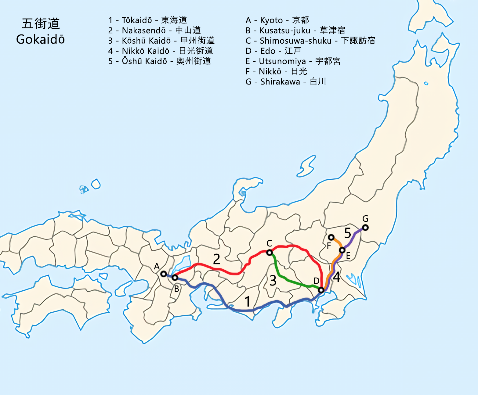
Two of the kaidō, the Nakasendō – which can be translated into “central mountain route”, and the Tōkaidō – which means “eastern sea route”, were both roads used for travel between Edo and Kyoto. The Tōkaidō route followed the southern coastline, more or less, while the Nakasendō took a more northernly path and traversed the inlands across the central parts of the island. Both of these routes had their own set of challenges. The Nakasendō, also known as the Kisokaidō route, ie the route through the Kiso valley, was longer, hillier and steeper, but when travelling along the Tōkaidō you needed to ford a lot more very wide and difficult rivers without the assistance of any bridges, which presented a different set of problems.
The importance of these routes diminished with the advent of railway tracks criss-crossing the countryside in the mid- to late 19th century, and their political importance disappeared completely during the same time, but for over 250 years they flourished and breathed life into the countryside.
Each route was divided into parts, with a shukuba, meaning a station town, or post town designated as an official resting place at the end and beginning of each section. The Nakasendō had 69 such shukuba along the route, of which the two closest to Kyoto were shared with the Tōkaidō. The Tōkaidō had 53 post stations along the path. The placement of these post towns depended on distance, but also on the relative difficulty of a particular stretch. If, for instance, there was a temperamental river to ford with no bridge and no ferry services, there could be a post town near the river on each side. They would have been close geographically as the crow flies, but from a travel effort perspective they would have been far apart in the pre-industrialised era.
Most of these post towns have now been lost to history in all but their names, having been swept by fires, remodeled and rebuilt, been swallowed by larger towns, or dwindled to a scattering of rural houses as the use of the trade routes diminished. The same goes for the road itself. In steep and remote areas, the old Nakasendō was often paved with large cobblestones, ishidatami, to make it easier for horses and carts to travel. While there are some shorter sections where these still remain, for the most part they have disappeared over time, for instance by having been replaced with asphalt and concrete, or that the original layout of the track has been lost.
Each shukuba had a number of different buildings to cater for the travellers, such as various types of inns and restaurants, as well as tea houses, stables and warehouses, and so on. Some of these places had special rules attached to them. The honjin for instance, were inns that were exclusively reserved for government officials. Waki-honjin were also reserved for these people, but had more leeway and could offer rooms to other kinds of wealthy travellers. The hatago were inns that offered rooms and services for all kinds of travellers. There are a number of places along the Nakasendō were some of these buildings are still extant, and in some cases even open to the public as museums, or even still being run as inns or ryokan. The size and importance of a particular shukuba was often measured in how many hatago, honjin and waki-honjin it had.
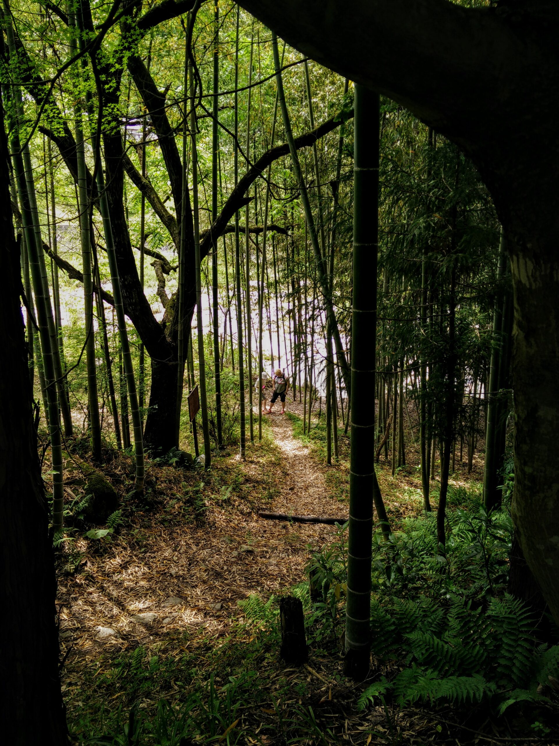
The old Nakasendō route can still be traversed by dedicated hikers. There are only a few parts of it that completely retain their old Edo period charm with wooden houses, cobbled roads or winding forest trails, but there is still a lot to see and experience elsewhere as well. When the Nakasendō crosses pastoral landscapes and villages, when it cuts across modern cityscapes of concrete and steel, and when it winds its way though the Japanese countryside over hills, following deep valleys, and along meandering rivers, you are connected to the travellers of old. Even in the hyper-modern, neon-lit parts of Tokyo you can still find waymarkers and milestones that remind us of the old Nakasendō route amidst the hectic hubbub of the metropolis.
The Nakasendō and a slice of Japan awaits you and your adventure!