Researching the old path has been an adventure in itself. There are a lot of versions of the complete route available on the internet, often only subtly different from each other. Sometimes though the various maps and files are starkly different, with long stretches of the path that don’t align with each other. I have tried to reconstruct a version as faithful as possible to where people used to walk along the road during the Edo period, weighing the veracity of a number of these sources. The best singular source of information is from the director of the “Nakasendō 69 station museum”, Yutaka Kishimoto. He has published a book on the topic, divided into two volumes called the Nakasendō Romantic Journey: West Section and the Nakasendō Romantic Journey: East Section. The revised editions I have used were published in 2024. These volumes provide a wealth of information on what landmarks the Nakasendō passed by; which stretches of the original path have been destroyed by railways, highways, new bridges, and so on; and what a traveller in the old days would expect to see and encounter. So every time online sources have differed, or made seemingly weird choices, these books have helped me find a course as true as possible to the original layout of the Nakasendō. This is the one presented here in the Resources section, and one which I will try to hike.
In spite of all that, it isn’t possible to hike a 100% true version of the Nakasendō anymore. As mentioned, new roads, new bridges, new houses, new railways, and more, have made that impossible. There is even an instance where the original old Nakasendō path nowadays passes right through a shopping mall! The path that I have chosen tries to account for these changes as well as possible.
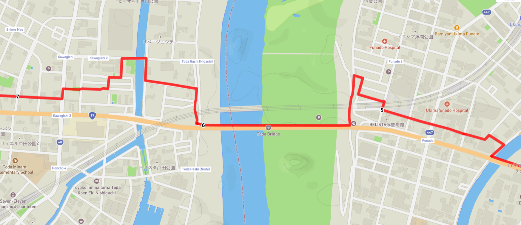
A great example of the difficulties of mapping a “true path” is shown in the map above. It displays a part of the second leg near Tokyo, between Itabashi-shuku and Warabi-shuku where the Nakasendō in short order crosses three rivers, from south to north: the Shingashi, the mighty Arakawa, and the Shobu. There were no bridges across any of these three rivers during the Edo period, and travellers had to use ferry services. The original path was an (almost) straight line between the “5”-kilometre and the “7”-kilometre points as marked along the red line in the picture. Today hikers have to weave their way through a dense cityscape of streets and back alleys in order to follow the old route as well as possible, making detours to cross the rivers on bridges, and rounding railways and huge buildings. Could you just keep hiking on the National Route 17 and ignore the twists and turns? Sure, but the idea of hiking along the old Nakasendō for me is to always follow the original path where it is physically possible, even if it makes the path longer in total.
Mapping issues aside, if you take the easiest route forward, in this instance following the National Route 17, you will also risk missing a lot of old stone markers, information boards and other remnants and memorials of the old Nakasendō. For instance, in the example above there are information boards and standing stones marking the places where the docks were for passage across the Arakawa river, and they are not on the modern highway!
As mentioned above, on the Resources page you can find all the 70 legs of the path in GPX-format, as well as a host of other files to download.


Leave a Reply